Built for the teams who map the real world.
The same end-to-end pipeline, tuned to the decisions each sector has to make.
Federal & national mapping
Nationwide base maps, land registry and situational awareness from a single sensor-to-twin pipeline.
Municipal & state
Urban digital twins for planning, climate adaptation, greening and CO₂-reduction decisions.
Automotive & autonomy
HD, SD and OpenDRIVE road networks for ADAS validation, routing and simulation.
Civil engineering
Survey-grade ortho, DSM/DTM and 3D for design, monitoring and as-built verification.
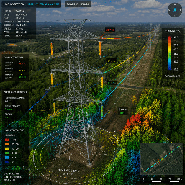
Energy & utilities
Powerline, pipeline and grid inspection with change detection and vegetation encroachment alerts.
Defense & intelligence
Rapid AOI tasking, object detection & tracking, and 3D for mission rehearsal.
Agriculture & forestry
Crop health, yield, biomass and forest monitoring with multispectral & thermal indices.
Insurance & risk
Pre- and post-event imagery, damage assessment and exposure modelling at portfolio scale.
NGOs & environment
Deforestation, water and disaster monitoring with transparent, explainable AI evidence.
Telecom & 5G
3D city models & clutter for radio planning, line-of-sight and rollout optimisation.
Mining & resources
Volumetrics, slope stability and site change from repeat survey & LiDAR.
Real estate & AEC
Context models, solar & shadow studies, and immersive stakeholder visualisation.
One ground truth, every department.
When imagery, maps, 3D and the twin all reference the same data, planning, operations and field teams finally work from one picture of reality — and decisions get faster.
- Shared, versioned source of truth across teams.
- Explainable AI evidence for audits and approvals.
- Scales from a single site to a whole country.
Let's map your world.
Send us your area of interest and what you need to see. We'll return a sample over your own location and walk you through the platform.